MAPSERVICES for route and tour planning
MAPSERVICES for optimal truck routing and route planning
Geographic services and optimizations for transport logistics – simply from the cloud
The MAPSERVICES provide various geographic information and optimization tools for easy use directly from the cloud for transport logistics, from truck routing and route planning to route optimization. Most free online map services provide functionalities for private use, our software services are specially optimized for logistics – especially for truck routing.
Truck attributes, toll information, truck speed profiles
We start where free map services end. Our maps take truck attributes into account for truck routing or calculate driving times based on specialized truck speed profiles and provide toll information as required for professional truck routing.

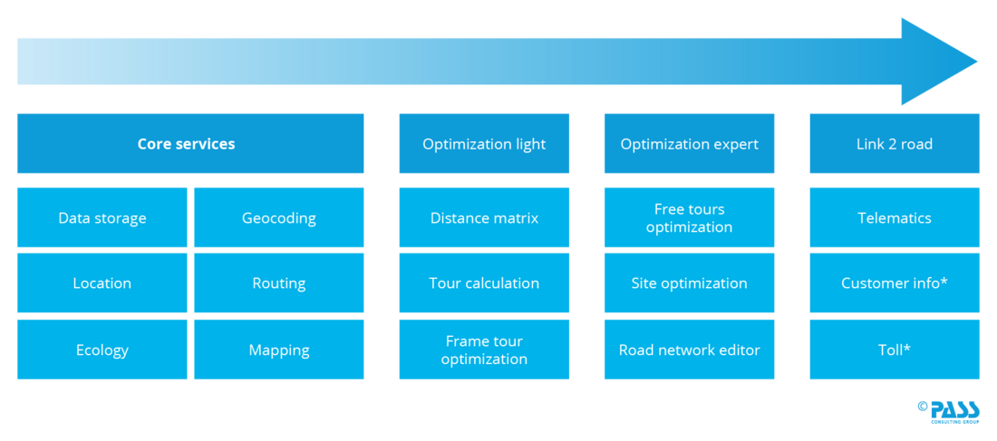
MAPSERVICES' professional logistics services are designed as cloud building blocks and can be easily integrated into individual applications: Do you want to use address validation, truck route planning or route optimization directly in your ERP, TMS or self-developed dispatching tool? We integrate MAPSERVICES via a secure REST API from the cloud into your system landscape. This gives you a unified view of logistics data across your company and allows you to work with consistent values across all systems.
A solution that grows with you
License the MAPSERVICES building blocks you need and leverage the power of PASS Cloud to dynamically grow with your needs. A simple asset-based SaaS licensing model gives you full cost transparency. Do you have stringent IT security requirements? Our ISO-certified data centers offer you a secure service out of Germany.
Historical speed data
Since planning is done for the future, live traffic data does not help. That's why we have historical data for more than 99.9% of the major road classes in Europe.
Consideration of vehicle classes
Whether car, truck or cargo bike - we take vehicle-specific restrictions and dangerous goods information into account. On this basis, we calculate individual networks and also include the topic of e-mobility in the planning.
Address information accurate to the house number
Accurate planning requires precise location: Several million points of interest (POI) help to find addresses more easily.
Building geometries
Especially in graphical geocoding, up-to-date building geometries help dispatchers find the right point to locate.
Construction site information
Permanent construction sites and long-term road closures often ruin optimal planning. In the daily updated service we provide road network updates, so that the planning also corresponds to reality.
Live traffic information
Even if they are only of limited help for planning, live data provide considerable added value when it comes to ETA (Estimated Time of Arrival) and thus also with regard to the ability to meet service times.
At the heart of MAPSERVICES are our optimization algorithms PASS Optimization Services (POS). They work with artificial intelligence (AI) and enable
- a high flexibility in the control of the result by a configurable objective function as well as
- fast extensibility for individual optimization requirements.
The algorithms are designed to replicate dispatching and planning strategies as a real dispatcher would perform them - at many times the speed. At the same time, they have a "memory" and learn from the replenishments of human planners.
The basis for our MAPSERVICES is the map material of TomTom, which is updated several times a year. However, digital maps are outdated as soon as they are published: wandering road works, road closures but also errors in digitization (e.g. wrong clearance height) lead to plan deviations again and again. Therefore, we update our cloud-based maps with road closures on a daily basis. Additionally, users can add individual road closures or change road properties. As a customer, you determine whether you want to build on the basic road network or have daily updated road works imported.
![[Translate to Englisch:] Flexibles und aktuelles Straßennetz](/fileadmin/_processed_/c/1/csm_PASSMapservice_Strassennetz_desktop_en_f7286be469.png "[Translate to Englisch:] Flexibles und aktuelles Straßennetz")
Our MAPSERVICES also offer services that generate long-running calculations. When such a calculation is triggered, you receive a reference to the data storage, via which progress, intermediate results and final results can be queried and stored.
- Asynchronous calculation with intermediate results
- Storage of results for further processing
An essential function for geoservices is geocoding. Here addresses are translated into geo-coordinates (forward geocoding) or coordinates into addresses (backward geocoding). At the same time, many additional functions are provided. The database of our search includes millions of addresses and POIs (Point of Interest) with exact house numbers:
- Forward and backward geocoding with fuzzy search, suggestion lists and auto-correction for single records or in a batch
- Structured and unstructured search
- POI search by name, category or along a route
- Postal code search
- Support of multilingualism in search and results
An elementary function of the route optimization is the underlying routing. Here it is necessary to determine the "optimal" route between two points (geo-coordinates). Depending on the vehicle and time of day, however, this can vary:
- Meter-precise and second-precise calculation of routes within milliseconds based on historical speed information.
- Consideration of different profiles (car, truck, cargo bike) incl. type-specific restrictions
- Special route calculation for areas with restricted access such as pedestrian zones or forest and field paths
- Designation of toll routes
In addition to the calculation of geopoints, routes or tours, a visualization on a map is usually desired. This is the purpose of the Mapping Service. The service provides map graphics and layers to create sophisticated map displays using state-of-the-art tools and graphics libraries:
- Tiles Server in x/y/z format
- Configurable display of POIs on the map
- Visualization of live traffic information
- Display and information regarding road closures, road works etc.
- Display of vehicle-specific road network restrictions such as clearance heights, water protection areas, etc.
- Visualization of prohibited maneuvers (e.g. left turn prohibition)
As soon as routes or tours are to be calculated or optimized, a distance matrix is needed. Here, all possible distances for all combinations are calculated for a set of geo-coordinates or addresses:
- Calculation of symmetrical and asymmetrical matrices and vectors with the most modern high-speed algorithms
- Consideration of historical speed data and thus calculation of time-dependent matrices
- Consideration of vehicle types and dimensions
Even without optimization, the correct and complete pre- or post-calculation of a tour is challenging. If a sequence of stops is given, breaks and waiting times, e.g. at time windows, have to be considered in addition to the driving and service times at the stop points for a complete calculation:
- Complete time, distance and cost calculation of a tour for a given stop sequence incl. display of CO2 emissions and toll information.
- Consideration of different break modes: fixed times, flexible breaks (e.g. 30 min between 11:00 and 13:00, where it fits best), based on driving and working times
- Calculation of capacities, workloads and designation of violations regarding restrictions, capacities and time windows
- Consideration of vehicle types and profiles as well as time-dependent driving times
In framework route planning, delivery orders are planned on an existing route framework. This can offer different degrees of freedom for optimization. At one extreme, orders can be assigned to a vehicle in a fixed sequence and only the resulting tours are calculated. At the other extreme, there is only a loose binding and stops can be swapped in sequence. Frequently, dispatchers still intervene after planning has been completed and resolve conflicts or violations manually. It is precisely for this purpose that our service offers the unique feature of "intelligent framework tour planning". Here, the AI mimics typical actions of a dispatcher to resolve conflicts while changing the existing framework as little as possible:
- Full-fledged framework tour planning with tour and sequence specifications.
- Consideration of restrictions, vehicle types incl. historical speed data, time windows as well as designation of violations
- AI-based, intelligent frame tour planning for automatic resolution of violations
Tour optimization with all degrees of freedom and configuration options. A configurable cost function and planning specifications can be used to influence the result in a targeted manner. The AI-based PASS Optimization Service (POS) offers a comprehensive set of possibilities and can be extended with additional requirements if necessary:
- Planning of inbound, outbound and pick-up and delivery tours.
- Consideration of any vehicle, driver and order restrictions
- Consideration of vehicle type and time-dependent driving times
- Consideration of service times, time windows, break regulations, operating times and driving and working times
- Consideration of any dimensions and capacities incl. strategies for the resolution of overcapacities such as commuting, targeted over-scheduling or sorting out of orders
- Planning of one-day or multi-day tours with single and multiple vehicle deployment
- Consideration of trailers and trailers
PASS uses the MAPSERVICES on a professional road network from TomTom including logistic special attributes like passage restrictions and truck attributes. The road network is updated by PASS several times a year. Furthermore, road closures and construction site information are included in the road network on a daily basis. With the road network editor, customers can additionally change the attributes of the network and thus influence the resulting route guidance:
- Perform individual road network changes within seconds.
- Based on the basic network for strategic planning or the daily updated roadwork network for operational planning
- Unilateral or complete closure of roads
- Change of restrictions (weight, height, width etc.) and average speed
- Fine granularity on individual road segments
In addition to route optimization, POS also solves the strategic problem of location optimization independent of capacities and assortments. Here, optimal customers to depot assignments are determined and strategic location questions such as depot opening, relocation or closure are answered:
- Determination of optimal customers to depot assignment on the basis of actual commuting times and delivery frequencies.
- Optimization and restructuring of sales territories
- Strategic simulation of depot changes
After the planning of tours, the exact execution of the tours is important in order to experience the planned effects in practice. For this purpose, there are a number of telematics providers on the market with different strengths. Many companies also have their own apps for driver control. Our telematics service enables the transparent connection of a telematics provider via a standardized format. In this way, plan data simply comes to the driver's mobile device and live data simply comes back, enabling simple controlling and finding deviations between plan and actual. Currently, a large number of telematics connections already exist, and further connections can usually be implemented in a short time:
- Standardized data exchange with telematics systems
- Simple and permanent comparison of planning and live data
- Calculation of ETA times for running tours
- Transparent exchange of telematics service providers
- Mixed operation of telematics systems via an interface, e.g. when differentiating between own and external fleets
You plan and drive, we inform your customers about it. Simply send order notifications based on pre-planning and updates based on actual live tours:
- Uniform customer notification with desired text and formatting based on planning data.
- Delivery info based on live data with geofencing or ETA based (e.g. 30 min before arrival)
- Dispatch via e-mail or SMS (additional costs) with own or standard PASS sender
*This service is expected to be available from Q4/23.
In the standard package, MAPSERVICES provides toll information on routes and tours. The exact length of the toll route is shown for each segment. The toll service links this information to a vehicle and calculates the expected toll costs for a tour based on current toll tables:
- Vehicle-specific calculation of toll costs for a given route or tour
- Consideration of the different toll models in Europe
- Detailed comparison with actual toll costs (requires Toll Collect data)
*This service is expected to be available from Q1/24.
Simply from the PASS Cloud
You do not need your own infrastructure, only an internet access to use the MAPSERVICES. Communicate with our https-based REST services with JSON objects or our web app.
Always up-to-date map data
We make sure that you always work with up-to-date road network data. There are no downtimes for you due to updates of the system or incorrect driving of your vehicles.
Simple licensing model
The usage fee is calculated transparently based on the size of your fleet and the services used. Request your calculation without obligation and benefit from our subscription model.
Secure authentication
Communicate 100% secure over SSL encrypted connections in both the web app and the REST API and use our OAuth2-based authentication with JSON Web Tokens.
Your data is secure
Use our DSGVO-compliant service in ISO-certified data centers in Germany. Your data will not be stored longer than necessary for the calculation. We work completely without personal data.
Simple online documentation
As a developer, integrate the MAPSERVICES quickly and easily by using the online documentation according to the OpenAPI 3.0 standard and test the API directly in the browser.